


Neighborhood in Albuquerque · Bernalillo County
Los Volcanes
Los Volcanes is a neighborhood on Albuquerque's Westside, offering a combination of residential streets, apartment communities, commercial properties, and convenient access to Interstate 40.
Photo 1 of 1

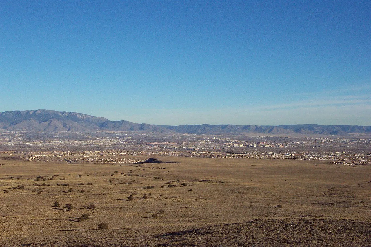
Regional context: Albuquerque viewed from the West Mesa volcanoes. This landscape is not a photograph of the neighborhood’s residential streets.
Regional context: Albuquerque viewed from the West Mesa volcanoes. This landscape is not a photograph of the neighborhood’s residential streets.
Creator: Clinton Steeds from Los Angeles, USA
License: CC BY 2.0
Clinton Steeds from Los Angeles, USA
Changes: Source-supplied resized rendition imported; re-encoded as WebP/AVIF for delivery. No content edits.
Westside housing, recreation and mixed employment corridors
About Los Volcanes
Los Volcanes is a neighborhood on Albuquerque's Westside, offering a combination of residential streets, apartment communities, commercial properties, and convenient access to Interstate 40.
StrollPlace walkability
43/ 100
The middle 80% of residents in the estimate lived on blocks that scored 31–60.
Estimated access on foot to everyday destinations.
About this estimate
Destinations include groceries, pharmacies, parks, transit stops, cafés, restaurants, shops and schools. The range covers the middle 80% of residents in the estimate.
We estimate the walking distance from each populated Census block’s reference point to the nearest mapped place in each category. A walk of five minutes or less earns full credit. Credit falls to zero at 20 minutes. Groceries count for the most. The area score weights each sampled block by its Census population.
We could route from 17 blocks representing 100% of the area’s reference population. The model estimates route distance and uses a fixed walking speed. Sidewalk condition, shade, and crossing comfort are outside this version’s scope.
Living in Los Volcanes
Los Volcanes is a neighborhood on Albuquerque's Westside, offering a combination of residential streets, apartment communities, commercial properties, and convenient access to Interstate 40.
Unlike neighborhoods made up almost entirely of single-family homes, Los Volcanes has a mixed residential and employment-oriented character. Some streets feature Southwestern-style houses and private yards, while other sections contain warehouses, distribution facilities, and commercial businesses.
For prospective residents, the key considerations are housing conditions, proximity to industrial activity, commuting across Albuquerque, and access to groceries, schools, recreation, and healthcare.
Location and Neighborhood Character
Los Volcanes is located in western Albuquerque, primarily within the 87121 ZIP code.
A City of Albuquerque economic development study describes the broader Los Volcanes area as extending approximately from Interstate 40 to Central Avenue and from Coors Boulevard to 98th Street.
The boundaries of the officially recognized Los Volcanes Neighborhood Association may differ from those used in economic development studies or real estate listings. Buyers should verify whether a particular address falls within the association's mapped boundaries.
Residential areas include streets near Los Volcanes Road, Fortuna Road, Bluewater Road, and surrounding developments.
The neighborhood's location near Interstate 40 and Coors Boulevard makes it accessible to major employment and commercial destinations.
However, the mixture of residential and nonresidential land uses means the environment can vary substantially from one street to another.
Housing and Residential Options
Los Volcanes offers both single-family homes and apartment communities.
Much of the area's newer residential development dates from the late 1990s through the 2010s, although construction periods vary by property.
Houses commonly feature Southwestern and Pueblo-inspired designs, stucco exteriors, attached garages, private yards, and desert-adapted landscaping.
Rental options include apartment communities such as Volcanes Commons and Bluewater Village.
Compared with older Albuquerque neighborhoods, some residential properties may have more contemporary floor plans and construction systems.
However, newer construction does not eliminate the need for careful inspections.
What Should Buyers Check?:
Before purchasing a home, review:
Roof condition and previous repairs.
Stucco finishes and drainage.
Heating and cooling systems.
Plumbing and electrical installations.
Landscaping and irrigation.
Garage capacity and driveway access.
Previous renovations and permits.
Applicable covenants or homeowners association requirements.
Because commercial and industrial activity is present in parts of Los Volcanes, buyers should also investigate the uses of neighboring properties.
A house located on an interior residential street may offer a different experience from one near a warehouse, major road, or distribution facility.
For renters, important questions include parking availability, utility responsibilities, maintenance policies, building security, and noise conditions.
Groceries, Shopping, and Everyday Essentials
Los Volcanes residents have access to grocery stores and everyday businesses along nearby Coors Boulevard and Central Avenue.
Smith's Food & Drug — 111 Coors Boulevard NW
A full-service supermarket offering groceries, fresh produce, household products, and other daily necessities.
Additional retail businesses, restaurants, and personal services operate along the surrounding commercial corridors.
The area also contains smaller shopping centers and convenience-oriented businesses.
However, everyday shopping is not equally accessible from every residential street.
Some apartments may be located relatively close to businesses, while other properties require a longer walk or drive.
For residents who prefer not to use a car for every errand, checking pedestrian crossings, sidewalks, and bus-stop access is particularly important.
Parks, Outdoor Recreation, and Swimming
Los Volcanes offers access to city recreation facilities and public parks, although the area is not dominated by extensive residential green space.
Laurelwood Park:
Laurelwood Park, at 7440 Hanover Road NW, is a public park in the nearby Westside residential area.
It provides an option for outdoor activities and neighborhood recreation.
Another nearby location is Lavaland Park, at 319 64th Street NW.
However, the City of Albuquerque currently lists Lavaland Park as temporarily closed for security upgrades. Residents should verify its reopening before planning regular visits.
West Mesa Aquatic Center:
West Mesa Aquatic Center, at 6705 Fortuna Road NW, is one of the area's most useful public recreation facilities.
The center includes:
An Olympic-size swimming pool.
Indoor recreational swimming.
Water slides.
Swimming lessons and aquatic programs.
Lap swimming and water exercise.
Facilities for swimming competitions.
This provides an option for residents interested in year-round swimming and family recreation.
Pool schedules, admission arrangements, and available activities vary, so visitors should check current information before attending.
Exploring Albuquerque's Volcanoes:
Los Volcanes takes its name from the volcanic landscape associated with Albuquerque's West Mesa.
The Volcanoes Day Use Area, part of Petroglyph National Monument, is located farther northwest and is not a neighborhood park.
It provides trails around volcanic cinder cones and views across Albuquerque.
Visitors should know that the trails are on natural, uneven terrain, there is no drinking water, bicycles are not allowed on the trails, and pets must remain on leashes.
The Volcanoes Day Use Area does not contain petroglyph-viewing trails.
For residents who enjoy hiking, it can be an interesting regional destination, but reaching it generally requires a separate trip.
Schools and Education
Los Volcanes is located within the Albuquerque Public Schools district.
Several public schools serve the broader Westside area.
Susie R. Marmon Elementary School — 1800 72nd Street NW — A public elementary school serving the surrounding community.
John Adams Middle School — 5401 Glenrio Road NW — A public middle school offering academic and extracurricular programs.
Jimmy Carter Middle School — 8901 Bluewater Road NW — Another public middle school in the broader Westside area.
West Mesa High School — 6701 Fortuna Road NW — A public high school serving grades 9–12.
These schools are nearby educational references, not guaranteed assignments for every address.
Families should verify elementary, middle, and high school assignments using the official APS boundary lookup before renting or purchasing.
Some schools and specialized educational programs may have separate enrollment requirements.
Parents should also consider transportation arrangements, after-school care, and the availability of activities near their chosen home.
Children's Activities and Community Programs
The surrounding area provides several resources for families seeking structured activities.
West Mesa Community Center:
West Mesa Community Center, at 5500 Glenrio Road NW, offers community recreation and educational opportunities.
Facilities include:
A fitness room.
A mini gymnasium.
Arts and crafts space.
Classrooms.
A children's library.
A game room.
A computer lab.
The center also offers organized activities, with programs that may include fitness classes, creative workshops, and community events.
Community center membership is free, although particular activities may have separate registration or eligibility requirements.
Swimming and Youth Recreation:
West Mesa Aquatic Center provides another option for swimming and aquatic activities.
Families can also explore school-based sports, community recreation programs, and youth organizations operating throughout Albuquerque's Westside.
Before selecting a home, parents should check current program schedules, available spaces, age requirements, and travel distances.
Healthcare, Pharmacies, and Fitness
Medical services are available throughout western Albuquerque, although Los Volcanes is not a major hospital district.
One healthcare option in the broader area is:
First Choice Community Healthcare — Alamosa Health Center — 6900 Gonzales Road SW
The facility provides primary care, women's health, behavioral health, laboratory services, and other healthcare programs.
It is located south of Central Avenue, outside the main Los Volcanes residential area.
Residents should confirm appointment availability, insurance acceptance, and services directly with the provider.
Pharmacy services are available through area grocery stores and other commercial locations.
For exercise, West Mesa Community Center provides fitness facilities, while West Mesa Aquatic Center offers swimming and water-based exercise.
Los Volcanes Senior Center, at 6500 Los Volcanes Road NW, is another important community resource.
It offers senior-oriented programs, meals, social activities, and access to the nearby Los Volcanes Sports & Fitness Center.
Eligibility and program participation requirements should be confirmed directly with the city's Department of Senior Affairs.
Transportation, Commuting, and Parking
Transportation is one of the most important factors to evaluate before moving to Los Volcanes.
Driving and Highway Access:
Interstate 40 provides an important east-west connection, while Coors Boulevard links the area with other parts of western Albuquerque.
This can be useful for people commuting to Downtown, employment centers, or other destinations across the metropolitan area.
However, easy highway access does not guarantee a short commute.
Travel times can vary during peak periods, particularly when crossing the Rio Grande or traveling through major interchanges.
Prospective residents should test their regular routes during weekday commuting hours.
Public Transportation:
ABQ RIDE operates services along nearby major roads, including:
Route 155 — Coors, serving the Coors Boulevard corridor.
Route 66 — Central Avenue, providing east-west connections.
ART routes 766 and 777, serving the Central Avenue corridor and connecting with other parts of Albuquerque.
Access depends on the particular property.
For some residents, walking to a bus stop may be practical. Others may need a car or bicycle to reach useful transit connections.
ABQ RIDE operates fare-free local bus service, but route alignments and schedules can change.
Walkability and Cycling:
Los Volcanes is generally more car-oriented than central Albuquerque neighborhoods.
Residential streets can be suitable for neighborhood walks, but reaching supermarkets, schools, and other daily destinations may involve longer distances and busy roads.
Some sections also have commercial driveways and truck traffic that affect pedestrian and cycling conditions.
Before moving, check the availability of sidewalks, street crossings, bicycle connections, and direct routes to the destinations you expect to use regularly.
Parking:
Many single-family homes have garages or driveways.
Apartment communities may provide assigned parking, shared lots, or separate visitor-parking arrangements.
Renters should confirm parking availability and any restrictions before signing a lease.
Safety, Industrial Activity, and Property Considerations
Safety should be evaluated using current information for the specific address rather than assumptions about the neighborhood as a whole.
The Albuquerque Police Department provides crime mapping and statistics, but calls-for-service data should not be treated as a complete record of confirmed crime.
Residents should consider exterior lighting, traffic conditions, building security, and pedestrian access.
Living Near Commercial or Industrial Properties:
An important characteristic of Los Volcanes is the presence of warehouses, distribution facilities, and other employment-related land uses.
This does not mean that every residential street experiences substantial industrial activity.
However, properties near major commercial roads may be affected by:
Delivery trucks and commercial vehicle traffic.
Early-morning or evening business operations.
Noise from loading areas or equipment.
Lighting associated with commercial properties.
Changes in traffic associated with future development.
Before choosing a home, visit the surrounding streets on weekdays as well as weekends.
Also review current zoning, nearby vacant lots, and approved development plans through the City of Albuquerque.
Drainage and Home Maintenance:
Albuquerque's high-desert climate brings intense sun exposure and occasional heavy summer rainfall.
Buyers should evaluate roof conditions, exterior drainage, irrigation, and possible signs of water intrusion.
Properties near drainage channels or low-lying streets may require additional attention to flood exposure and runoff.
Flood risk should be checked at the property level using official maps and inspection findings.
Pros and Considerations
What residents may appreciate:
Access to Interstate 40 and Coors Boulevard.
A mixture of single-family homes and apartments.
Southwestern-style residential architecture.
West Mesa Aquatic Center and community recreation programs.
Grocery stores and daily services along nearby commercial corridors.
Public schools and community facilities in the broader area.
Access to outdoor destinations on Albuquerque's West Mesa.
What deserves closer attention:
Industrial and commercial activity near some residential properties.
Potential truck traffic and road noise.
Dependence on a car for many daily errands.
Traffic delays during peak commuting periods.
Uneven pedestrian access to stores and transit.
Property-specific school assignments.
Maintenance conditions, zoning, and future development nearby.
Is Los Volcanes Right for You?
Los Volcanes offers a residential option on Albuquerque's Westside with access to major transportation routes, shopping, public schools, and recreation facilities.
It may appeal to residents who value highway connections, suburban-style housing, and nearby public swimming and community programs.
However, the neighborhood's mixed land use makes choosing the exact address particularly important.
A home on a residential street may provide a very different everyday experience from an apartment close to a major commercial road or warehouse.
Before buying or renting, visit the property during different times of day, evaluate traffic and noise, check school assignments, and test your commute.
Los Volcanes is best evaluated street by street. The right home should offer not only the housing features you want but also a surrounding environment that supports your daily routine.
This guide is intended for general relocation research. Neighborhood boundaries, school assignments, business operations, recreation programs, transit schedules, property conditions, and local regulations may change. Verify important details for the exact residential address with relevant authorities, service providers, or qualified professionals before making housing decisions.
Compare surrounding Albuquerque areas
Explore the linked profiles to compare housing settings, public services and everyday travel in surrounding areas. Nearby areas can have overlapping names or different jurisdiction and property rules.
Neighborhoods and districts near Los Volcanes
The closest neighborhoods and districts in Albuquerque, measured center to center.


Sources & data notesReferences, reporting periods, and how to use this information
Information on this page is compiled from multiple sources and provided for general information. It may be incomplete or out of date, and we do not guarantee its accuracy, completeness, or timeliness. Independently verify important details with the original source, relevant authority, or a qualified professional before making decisions.
Statistics keep their reporting periods. Survey estimates are not current asking prices or quotes for an individual property. Displayed values are rounded.
- Local relocation research and address-specific verificationCity of Albuquerque — Los VolcanesSource checked
- Local relocation research and address-specific verificationCity of Albuquerque — West Mesa Community CenterSource checked
- Local relocation research and address-specific verificationAlbuquerque Public Schools — Attendance AreasSource checked
- Local relocation research and address-specific verificationfcch.com — Alamosa Health CenterSource checked
- Local relocation research and address-specific verificationCity of Albuquerque — West Mesa Aquatic CenterSource checked
- Local relocation research and address-specific verificationnps.gov — Vol.HtmSource checked
- Local relocation research and address-specific verificationCity of Albuquerque — Routes And SchedulesSource checked
- Local relocation research and address-specific verificationmsc.fema.gov — HomeSource checked
- Local relocation research and address-specific verificationCity of Albuquerque — Crime MappingSource checked
- Local relocation research and address-specific verificationCity of Albuquerque — ResourcesSource checked
- Local relocation research and address-specific verificationCity of Albuquerque — Park AddressesSource checked
- Association context; not a parcel boundary or mandatory HOA determinationCity of Albuquerque — Los Volcanes NA mapSource checked
- Branch schedules and current service availabilityPublic Library — locations and service noticesSource checked
- Local relocation research and address-specific verificationAlbuquerque homes — flat roofs, stucco and water damageSource checked
- Local relocation research and address-specific verificationAlbuquerque cooling — swamp coolers vs. refrigerated airSource checked
- Published school catalog information; verify address-based assignmentWest Mesa High — school profileSource checked
- Published school catalog information; verify address-based assignmentJimmy Carter Middle — school profileSource checked
- Published school catalog information; verify address-based assignmentSusie Rayos Marmon Elementary — school profileSource checked
- Published school catalog information; verify address-based assignmentJohn Adams Middle — school profileSource checked
- Compare nearby areas; neighborhood labels can overlapWest Mesa — area profileSource checked
- Compare nearby areas; neighborhood labels can overlapLaurelwood — area profileSource checked
- Compare nearby areas; neighborhood labels can overlapAlamosa — area profileSource checked
Photo credits
- Representative image. See the caption for the place shown.Regional context: Albuquerque viewed from the West Mesa volcanoes. This landscape is not a photograph of the neighborhood’s residential streets.Image credits and license
Regional context: Albuquerque viewed from the West Mesa volcanoes. This landscape is not a photograph of the neighborhood’s residential streets.
Creator: Clinton Steeds from Los Angeles, USA
License: CC BY 2.0
Clinton Steeds from Los Angeles, USA
Changes: Source-supplied resized rendition imported; re-encoded as WebP/AVIF for delivery. No content edits.