


District in Albuquerque · Bernalillo County
Near North Valley
Near North Valley is presented here in the city’s broader community-planning-area sense, between I-40 and Montaño and between the Rio Grande and I-25.
Photo 1 of 1

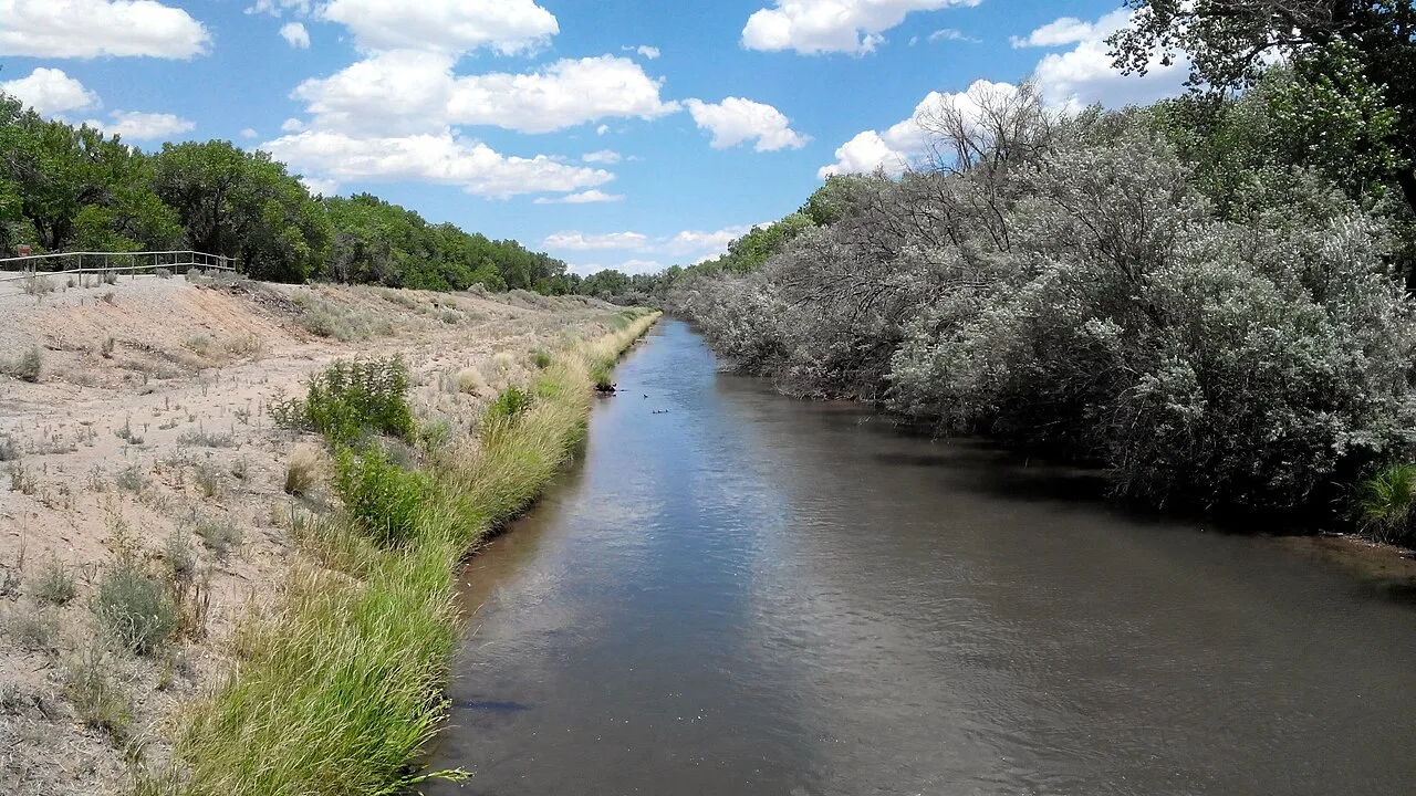
Waterway at Candelaria Farm, June 2014 — an agricultural landscape in the wider Near North Valley planning area.
Waterway at Candelaria Farm, June 2014 — an agricultural landscape in the wider Near North Valley planning area.
Creator: Aaron Zhu
License: CC BY-SA 3.0
Aaron Zhu
Changes: Source-supplied resized rendition imported; re-encoded as WebP/AVIF for delivery. No content edits.
A broad planning-area view of North Valley homes, waterways and city connections
Around the area
Around this district

About Near North Valley
Near North Valley is presented here in the city’s broader community-planning-area sense, between I-40 and Montaño and between the Rio Grande and I-25. It includes multiple neighborhoods and portions of different jurisdictions. Agricultural landscapes, residential streets and commercial corridors give its different parts distinct daily routines.
StrollPlace walkability
51/ 100
The middle 80% of residents in the estimate lived on blocks that scored 8–76.
Estimated access on foot to everyday destinations.
About this estimate
Destinations include groceries, pharmacies, parks, transit stops, cafés, restaurants, shops and schools. The range covers the middle 80% of residents in the estimate.
We estimate the walking distance from each populated Census block’s reference point to the nearest mapped place in each category. A walk of five minutes or less earns full credit. Credit falls to zero at 20 minutes. Groceries count for the most. The area score weights each sampled block by its Census population.
We could route from 68 blocks representing 97% of the area’s reference population. The model estimates route distance and uses a fixed walking speed. Sidewalk condition, shade, and crossing comfort are outside this version’s scope.
Overview
Near North Valley offers a distinctive residential setting in Albuquerque, combining established neighborhoods, traditional irrigation canals, and access to the Rio Grande with everyday city conveniences.
The city's Near North Valley Community Planning Area extends from I-40 to Montaño Road, between the Rio Grande and I-25. However, daily life can feel quite different depending on the street. Western sections retain more agricultural character and open space, while the 4th Street corridor provides shopping and services. Areas closer to the interstate highways have more commercial and industrial activity.
Housing and Neighborhood Character
Housing includes older adobe and Pueblo Revival-style homes, mid-century properties, conventional single-family houses, and some apartments. Larger residential lots are part of the area's historic landscape, although lot sizes and housing density vary.
For buyers, property condition deserves particular attention. Older homes may require closer inspection of roofing, stucco or adobe walls, plumbing, electrical systems, and heating and cooling equipment.
The neighborhood's historic acequias (irrigation ditches) are another important consideration. Properties near these waterways may have access easements, irrigation assessments, or maintenance-related restrictions. Buyers should verify any recorded obligations, water rights, and proposed improvements with the relevant authorities, including the Middle Rio Grande Conservancy District.
Properties may also fall under different municipal or county jurisdictions, so zoning and permitting requirements should be checked by address.
Schools, Preschool, and Children's Activities
Near North Valley is served by Albuquerque Public Schools (APS). Schools in the surrounding Valley High School cluster include:
Cochiti Elementary School and Griegos Elementary School — elementary education.
Garfield Middle School — middle-grade education.
Valley High School — high school education.
Duranes Early Childhood Center, 2436 Zickert Road NW — a dedicated APS Pre-K campus serving preschool-age children.
These schools are not automatically assigned to every property in Near North Valley. Families should verify attendance boundaries, enrollment eligibility, transportation, and available programs through the APS school lookup.
For after-school activities, Los Duranes Community Center, at 2920 Leopoldo Road NW, is a valuable neighborhood resource. Its facilities include a gymnasium, fitness room, dance room, computer lab, and arts and crafts space.
Programs include basketball, volleyball, pickleball, yoga, tai chi, and recreational activities. An after-school program serves children ages 5–15, with pickup arrangements from selected schools.
Community center memberships are free, with access to participating municipal facilities and classes. Registration, age restrictions, program availability, and any activity-specific requirements should be confirmed.
Nearby Los Griegos Library, at 1000 Griegos Road NW, provides books, educational resources, and public library programming. Its events calendar is worth checking for children's activities.
Parks, Nature, and Outdoor Recreation
Access to the Rio Grande bosque is one of Near North Valley's most appealing features.
Rio Grande Nature Center State Park, at 2901 Candelaria Road NW, offers wildlife viewing, birdwatching, gardens, educational exhibits, and access to adjacent trails. It is particularly useful for residents interested in nature education and outdoor activities.
Paseo del Bosque Trail provides approximately 16 miles of paved multiuse paths along the Rio Grande corridor, suitable for walking, jogging, and cycling.
Candelaria Nature Preserve offers protected open space and designated public access. Improvements to the Rio Grande Boulevard entrance include parking, an accessible trail, educational signs, seating, and a wildlife viewing platform.
Los Duranes Park, adjacent to the community center, provides additional neighborhood recreation space.
Not every property has equally convenient access to these destinations. Residents should check actual trail entrances, walking routes, and street crossings. The Nature Center also has admission rules and restrictions on pets.
Groceries, Healthcare, and Fitness
The 4th Street corridor is an important commercial area, with grocery stores, restaurants, and other local businesses.
John Brooks Supermarket, at 1130 Candelaria Road NW, is a grocery-shopping option within the area. Smith's Food and Drug, at 6125 4th Street NW, provides another supermarket option just north of the planning area.
For fresh produce and local goods, Los Ranchos Growers' Market, at 6718 Rio Grande Boulevard NW, operates seasonally, with a reduced winter schedule.
Healthcare services include UNM Family Health Clinic, North Valley, at 3401 4th Street NW. The location also provides an outpatient pharmacy and walk-in X-ray services.
Fitness opportunities include Los Duranes Community Center, with its fitness facilities and organized classes. Residents seeking private gyms or specialized training should compare options based on their exact address and preferred activities.
Transportation and Getting Around
Near North Valley has access to I-40 and I-25, providing connections to Downtown Albuquerque and other employment and shopping areas. However, travel times depend on traffic conditions and the specific location of a property.
Check the transit operator’s current timetable for this corridor, including service frequency and the last return trip.
Another useful option is ABQ RIDE Connect, a free, on-demand transportation service covering designated parts of the Rio Grande service zone. Rides can be arranged through the ABQ RIDE GO! app or by phone, subject to operating hours and service boundaries.
ABQ RIDE fixed-route buses are also fare-free.
Living without a car may be practical for some households near major routes and shopping, but other streets have limited sidewalks, longer distances between services, or less direct transit access. Parking availability and off-street spaces should be verified for each property.
Safety, Flooding, and Other Considerations
Safety conditions can vary by location and over time. Prospective residents should review the Albuquerque Police Department's crime mapping resources, visit prospective streets at different times, and examine traffic patterns, lighting, pedestrian crossings, and property security.
Police calls-for-service data do not represent every crime or establish the relative safety of an individual address.
Because Near North Valley lies within the Rio Grande corridor, buyers should also investigate drainage, flood exposure, and potential insurance requirements using the FEMA Flood Map Service Center.
Additional considerations include traffic noise near major roads, maintenance needs of older homes, and any irrigation easements or restrictions affecting land use.
Is Near North Valley a Good Fit?
Near North Valley offers an interesting combination of residential history, local services, access to outdoor recreation, and proximity to central Albuquerque.
Its advantages include a variety of housing styles, established community facilities, and access to the bosque. Potential trade-offs include uneven walkability, differences in nearby commercial activity, and the maintenance responsibilities associated with some older properties and larger lots.
Before choosing a home, verify the exact address for school assignments, transportation options, utilities, flood exposure, property condition, zoning, and nearby amenities. A street-level evaluation will provide a much clearer picture of everyday life than the neighborhood name alone.
This guide is intended for general neighborhood research. School boundaries, public programs, transportation schedules, business operations, and property conditions may change. Information should be independently verified and does not constitute legal, real estate, or safety advice.
Explore nearby neighborhoods and resources
Compare Alvarado Gardens, Los Griegos and Los Duranes for a wider view of nearby housing patterns, public resources and everyday routes.
Neighborhoods and districts near Near North Valley
The closest neighborhoods and districts in Albuquerque, measured center to center.
- Under 1 miStronghurstStronghurst is an established north-central Albuquerque neighborhood near Candelaria Road, with older homes and connections to the North Valley.
- Under 1 miMatthew MeadowsMatthew Meadows is a small residential neighborhood near Matthew Road NW and the Alameda Drain in Albuquerque’s North Valley area.


Sources & data notesReferences, reporting periods, and how to use this information
Information on this page is compiled from multiple sources and provided for general information. It may be incomplete or out of date, and we do not guarantee its accuracy, completeness, or timeliness. Independently verify important details with the original source, relevant authority, or a qualified professional before making decisions.
Statistics keep their reporting periods. Survey estimates are not current asking prices or quotes for an individual property. Displayed values are rounded.
- Planning-area extent; distinct from its constituent neighborhoodsCity — Near North Valley community planning areaSource checked
- Public recreation destinations and facility identityCity — public park locations and facilitiesSource checked
- Address-specific attendance and enrollment research · Verify enrollment by addressAPS — verify a school by home addressSource checked
- Current stops, service times and fixed-route transit information · Current stops, routes and travel timesABQ RIDE — current routes and schedulesSource checked
- Current branch access and library program calendarsABQ Library — current hours and locationsSource checked
- City-recognized association names; not an exact parcel or HOA boundaryCity — recognized neighborhood associationsSource checked
- School discovery; current attendance and program eligibility require confirmationValley High — school profileSource checked
- School discovery; current attendance and program eligibility require confirmationGriegos Elementary — school profileSource checked
- School discovery; current attendance and program eligibility require confirmationGarfield Middle — school profileSource checked
- School discovery; current attendance and program eligibility require confirmationCochiti Elementary — school profileSource checked
- Current dedicated early-childhood campusAPS — Duranes Early Childhood CenterSource checked
- Candelaria preserve, Los Poblanos Fields and agricultural public accessCity — North Valley farmlands and open spaceSource checked
- On-demand service zones, bookings and operating arrangementsCity — ABQ RIDE ConnectSource checked
- Related neighborhood discoveryAlvarado Gardens — neighborhood pageSource checked
- Related neighborhood discoveryLos Griegos — neighborhood pageSource checked
- Related neighborhood discoveryLos Duranes — neighborhood pageSource checked
- Citywide housing, school and transportation contextAlbuquerque — city overviewSource checked
- Published recreation destinationRio Grande Nature Center State Park — place pageSource checked
- Reference supplied in the articleaps.edu · what school should my child attendSource checked
- Reference supplied in the articlecabq.gov · crime mappingSource checked
- Reference supplied in the article · Address-specific flood mappingmsc.fema.gov · homeSource checked
- Parcel and jurisdiction lookupAlbuquerque and Bernalillo County GIS mapsSource checked
- Public park and recreation informationCity of Albuquerque parks and recreationSource checked
Photo credits
- Representative image. See the caption for the place shown.Waterway at Candelaria Farm, June 2014 — an agricultural landscape in the wider Near North Valley planning area.Image credits and license
Waterway at Candelaria Farm, June 2014 — an agricultural landscape in the wider Near North Valley planning area.
Creator: Aaron Zhu
License: CC BY-SA 3.0
Aaron Zhu
Changes: Source-supplied resized rendition imported; re-encoded as WebP/AVIF for delivery. No content edits.