


Neighborhood in Albuquerque · Bernalillo County
Nob Hill
Nob Hill runs along Central Avenue just east of the University of New Mexico.
Photo 1 of 1
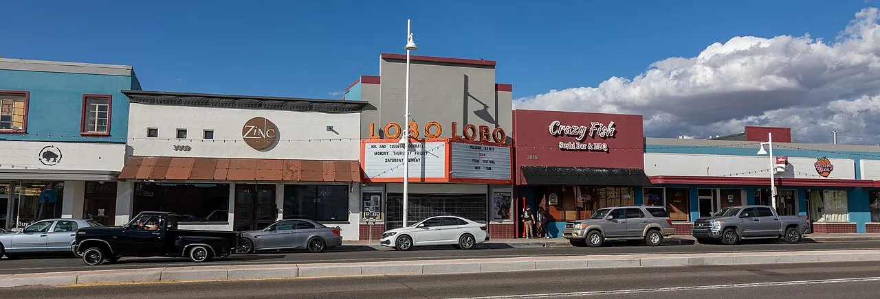
Lobo Theater and Central Avenue storefronts in Nob Hill — September 2024
Lobo Theater and Central Avenue storefronts in Nob Hill — September 2024
Creator: Kenneth C. Zirkel
License: CC BY 4.0
Changes: Resized and converted to WebP; card previews may crop the photo. Guide gallery preserves the full frame.
Route 66 buildings, neon gateways and Central Avenue transit
About Nob Hill
Nob Hill runs along Central Avenue just east of the University of New Mexico. Neon gateways, reused Route 66 buildings and locally owned shops and restaurants shape its commercial corridor, with residential streets nearby.
Central Avenue between the neon gateways
Nob Hill’s commercial corridor follows Central Avenue east of the University of New Mexico. Shops, galleries, restaurants and nightlife line this roughly mile-long stretch, which became part of Route 66 in 1937. Residential streets extend away from the avenue.
Neon arches mark the corridor at Girard and Washington. Artists Terry Conrad and Joan Weissman created these gateways in 1993 as a public art project, drawing on the signs associated with Route 66’s roadside businesses.
Service stations with a second life
Several of Nob Hill’s dining and coffee spaces retain the buildings of its motoring past. Little Bear Coffee and Wine Bar occupies the former Save Way service station, while Fan Tang uses the Andy Johnston Service Station. M’tucci’s Bar Roma is housed in the Jones Motor Company building, built in 1939.
The Nob Hill Business Center was completed in 1947 to a design by Louis G. Hesselden. Its drive-in shopping layout belongs to the same period when Central Avenue’s businesses increasingly served motorists. Together, the center and reused service stations make the Route 66 history visible in the present streetscape.
Two ART stations along the corridor
The Nob Hill ART station is at 3150 Central Avenue SE, and East Nob Hill is at 3730 Central Avenue SE. Both have center platforms and serve routes 766 and 777. The buses connect west through the university area and Downtown toward Central & Unser Transit Center.
Eastbound, route 766 continues to Uptown Transit Center, while route 777 stays on the Central corridor toward Tramway. ART currently has no fare. Marked, signalized crossings provide access to the platforms in the middle of Central Avenue.
Check these on a visit
Try these in person before you commit to an address in Nob Hill.
- Follow Central Avenue between the Girard and Washington gateways to see the Route 66 storefronts.
- Look for the former service stations now used by Little Bear, Fan Tang and M’tucci’s Bar Roma.
- Use the Nob Hill or East Nob Hill ART platform for a trip along Central Avenue.
Neighborhoods and districts near Nob Hill
The closest neighborhoods and districts in Albuquerque, measured center to center.
Guides about Nob Hill
Sources & data notesReferences, reporting periods, and how to use this information
Information on this page is compiled from multiple sources and provided for general information. It may be incomplete or out of date, and we do not guarantee its accuracy, completeness, or timeliness. Independently verify important details with the original source, relevant authority, or a qualified professional before making decisions.
Statistics keep their reporting periods. Survey estimates are not current asking prices or quotes for an individual property. Displayed values are rounded.
- Neighborhood setting and Central Avenue corridorVisit Albuquerque — Historic Nob HillSource checked
- Gateway locations, date and artistsNob Hill Main Street — Neon GatewaysSource checked
- Historic service stations and business centerVisit Albuquerque — Nob Hill on Route 66Source checked
- ART fares, routes and station locationsCity of Albuquerque — ART routes and stationsSource checked
Photo credits
- Lobo Theater and Central Avenue storefronts in Nob Hill — September 2024Image credits and license
Lobo Theater and Central Avenue storefronts in Nob Hill — September 2024
Creator: Kenneth C. Zirkel
License: CC BY 4.0
Changes: Resized and converted to WebP; card previews may crop the photo. Guide gallery preserves the full frame.