


Neighborhood in Charleston · Charleston County
Cannonborough/Elliottborough
Cannonborough/Elliottborough combines historic houses, apartments and corner businesses around Spring and Cannon streets on the Charleston peninsula.
Photo 1 of 1
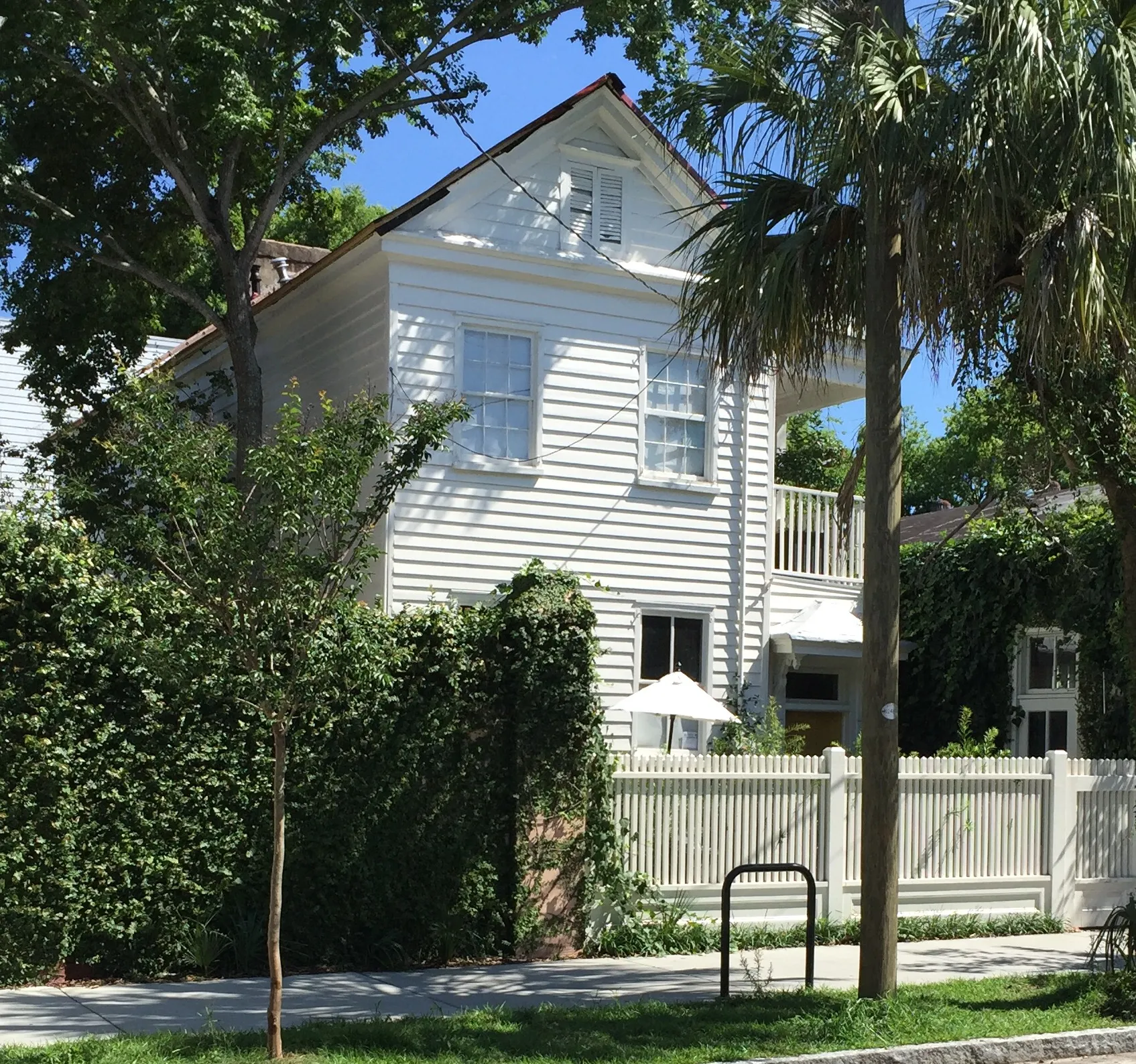
June 7, 2016: 59 Cannon Street, Charleston — ProfReader / Wikimedia Commons, CC BY-SA 4.0.
June 7, 2016: 59 Cannon Street, Charleston — ProfReader / Wikimedia Commons, CC BY-SA 4.0.
Creator: ProfReader
License: CC BY-SA 4.0
Changes: Resized and converted to WebP; may be cropped to fit the display
Historic housing, free peninsula buses, residential parking and grocery trips
About Cannonborough/Elliottborough
Cannonborough/Elliottborough combines historic houses, apartments and corner businesses around Spring and Cannon streets on the Charleston peninsula. The free DASH 213 follows Cannon Street and connects with the medical complex and other downtown destinations. City parking permits and separate visitor passes govern parking for residents and their guests.
Houses and apartments around Spring and Cannon
Spring and Cannon streets cross the neighborhood between the Ashley River approaches and Upper King Street. The city’s 2009 character appraisal documents Charleston single houses, freedmen’s cottages, apartment houses and larger homes divided into separate units. A historic exterior can therefore belong to a whole house, a condominium or one floor of a larger property.
The 2009 study covers the area from the Crosstown south to Bee and Morris streets, with President Street to the west and King Street to the east. Neighborhood labels farther east vary by source.
Resident permits and guest parking
The city’s residential permit program applies to designated parking districts. Within a district, each residential unit can receive up to two resident permits. Homeowners pay $15 per vehicle for the calendar year; renters pay $10 per vehicle for January–June or July–December.
A renter’s application requires a lease of at least six months, a driver’s license and qualifying vehicle documents; the city lists student and military alternatives. Visitor passes are separate: renters may buy up to fourteen one-day passes per residential unit in a six-month period, at $5 per day. Visitor passes are sold by mail or in person. The parking office at 180 Lockwood Boulevard handles appointments and questions at 843-724-7375.
Free DASH buses through the peninsula
CARTA’s free Downtown Area Shuttle route 213 follows Cannon Street eastbound and returns through Calhoun Street, with a loop past the medical complex, Lockwood Drive and the Citadel area. The map marks a timing point at Cannon Street and Ashley Avenue. A journey back can therefore use a different street from the outbound trip.
For City Market, Broad Street and Waterfront Park, route 211 follows the King/Meeting corridor farther east. The linked DASH map shows the direction arrows, timing points and connections; CARTA’s schedule directory carries the current brochure.
Groceries and pharmacy at WestEdge
Publix at 10 Westedge Street, Suite 100, is a grocery option west of the neighborhood toward Lockwood Drive and Brittlebank Park. It opens 7 a.m.–10 p.m. daily and has produce, a deli, bakery and curbside pickup. The store number is 843-720-7000.
The pharmacy keeps shorter hours: 9 a.m.–9 p.m. weekdays, 9 a.m.–7 p.m. Saturday and 11 a.m.–6 p.m. Sunday.
Short stays and residential leases
Part of Cannonborough/Elliottborough falls within Charleston’s Short Term Rental Overlay Zone. The city distinguishes commercially zoned short-term rentals from residential permit categories and bed-and-breakfast uses. That overlay helps explain why a search in the same area can return both residential leases and visitor accommodation.
The city’s category page links its peninsula map, while the Permit Center handles property-use and short-term-rental questions at 2 George Street.
Check these on a visit
Try these in person before you commit to an address in Cannonborough/Elliottborough.
- Ask the parking office about permit eligibility and arrange separate visitor passes for guests.
- For a DASH journey, note that route 213 uses Cannon eastbound and Calhoun on its return loop.
- A late grocery stop can run until 10 p.m.; the WestEdge pharmacy closes earlier.
Neighborhoods and districts near Cannonborough/Elliottborough
The closest neighborhoods and districts in Charleston, measured center to center.
Sources & data notesReferences, reporting periods, and how to use this information
Information on this page is compiled from multiple sources and provided for general information. It may be incomplete or out of date, and we do not guarantee its accuracy, completeness, or timeliness. Independently verify important details with the original source, relevant authority, or a qualified professional before making decisions.
Statistics keep their reporting periods. Survey estimates are not current asking prices or quotes for an individual property. Displayed values are rounded.
- 2009 architectural study, study-area limits and examples of homes divided into units
- Spring and Cannon corridor geography; plan adopted in 1998City of Charleston — Spring Cannon Corridor PlanSource checked
- Resident permit terms, documents and fees; separate renter visitor passes and office contactCity of Charleston — residential parking permitsSource checked
- Downtown district-based permit program and application link; linked overview map is dated 2017City of Charleston — residential parking programSource checked
- Current directory for free DASH routes and linked brochureCARTA — maps and schedulesSource checked
- Route 213 direction, Cannon/Ashley timing point, medical complex and Citadel loop; route 211 connectionsCARTA — DASH route map and schedulesSource checked
- Grocery address, store and pharmacy hours, departments and pickupPublix — 10 WestedgeSource checked
- Commercial overlay distinguished from residential categories; linked peninsula mapCity of Charleston — short-term rental categoriesSource checked
- 2 George Street and property-use/short-term-rental stationCity of Charleston — Permit CenterSource checked
- June 7, 2016 photograph; CC BY-SA 4.0 licenseProfReader — 59 Cannon Street photographSource checked
Photo credits
- June 7, 2016: 59 Cannon Street, Charleston — ProfReader / Wikimedia Commons, CC BY-SA 4.0.Image credits and license
June 7, 2016: 59 Cannon Street, Charleston — ProfReader / Wikimedia Commons, CC BY-SA 4.0.
Creator: ProfReader
License: CC BY-SA 4.0
Changes: Resized and converted to WebP; may be cropped to fit the display