


Neighborhood in Albuquerque · Bernalillo County
Route 66 West
Route 66 West is an established residential neighborhood on Albuquerque's Southwest Mesa, featuring suburban-style housing, neighborhood parks, and access to shopping and services along Central Avenue.
Photo 1 of 1

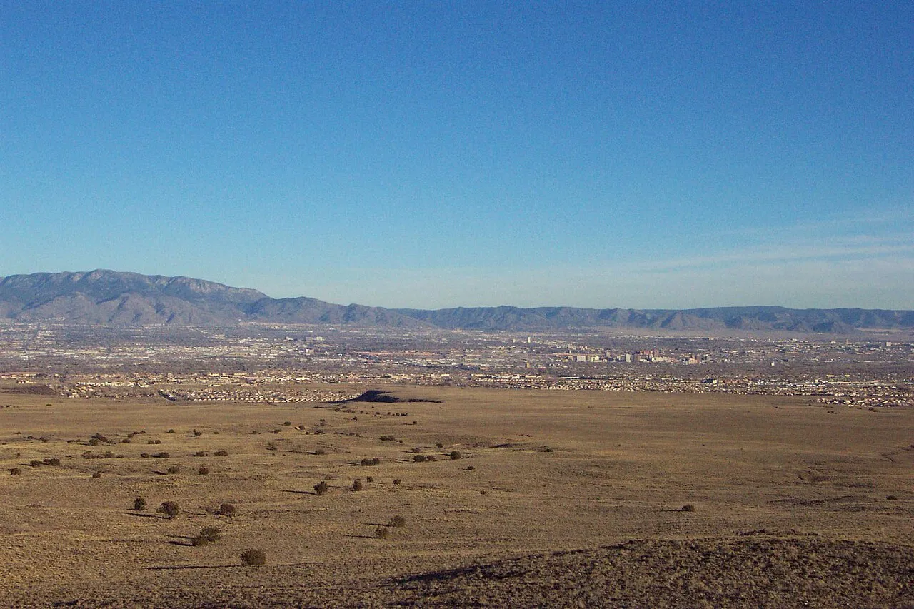
Regional context: Albuquerque viewed from the West Mesa volcanoes. This landscape is not a photograph of the neighborhood’s residential streets.
Regional context: Albuquerque viewed from the West Mesa volcanoes. This landscape is not a photograph of the neighborhood’s residential streets.
Creator: Clinton Steeds from Los Angeles, USA
License: CC BY 2.0
Clinton Steeds from Los Angeles, USA
Changes: Source-supplied resized rendition imported; re-encoded as WebP/AVIF for delivery. No content edits.
Southwest Mesa homes near Central Avenue and 98th Street
About Route 66 West
Route 66 West is an established residential neighborhood on Albuquerque's Southwest Mesa, featuring suburban-style housing, neighborhood parks, and access to shopping and services along Central Avenue.
StrollPlace walkability
30/ 100
The middle 80% of residents in the estimate lived on blocks that scored 14–54.
Estimated access on foot to everyday destinations.
About this estimate
Destinations include groceries, pharmacies, parks, transit stops, cafés, restaurants, shops and schools. The range covers the middle 80% of residents in the estimate.
We estimate the walking distance from each populated Census block’s reference point to the nearest mapped place in each category. A walk of five minutes or less earns full credit. Credit falls to zero at 20 minutes. Groceries count for the most. The area score weights each sampled block by its Census population.
We could route from 53 blocks representing 100% of the area’s reference population. The model estimates route distance and uses a fixed walking speed. Sidewalk condition, shade, and crossing comfort are outside this version’s scope.
Living in Route 66 West
Route 66 West is an established residential neighborhood on Albuquerque's Southwest Mesa, featuring suburban-style housing, neighborhood parks, and access to shopping and services along Central Avenue.
Although its name references the historic Route 66 highway, Route 66 West is primarily a residential community rather than a tourist district. The neighborhood includes single-family homes, local streets, and nearby commercial corridors.
For prospective residents, its Westside location provides access to everyday necessities and major roads. However, commuting distances, pedestrian convenience, public transportation, and housing conditions should be evaluated carefully.
Neighborhood Location and Character
Route 66 West is generally bounded by Central Avenue to the north, De Vargas Road to the south, 98th Street to the east, and 122nd Street to the west.
The neighborhood is part of Albuquerque's Southwest Mesa, an area that experienced substantial residential development during the late 20th century and afterward.
Interior streets include a mixture of cul-de-sacs, residential loops, and connecting roads. Properties typically feature Southwestern-style architecture, private yards, and driveway parking.
Commercial activity is concentrated along Central Avenue and nearby major intersections.
The Route 66 West Neighborhood Association was originally established in 2001 and reestablished in 2015. It has participated in neighborhood discussions and community initiatives.
The association's historical boundaries should not be confused with zoning districts, school attendance areas, or homeowners association boundaries.
Housing and Residential Living
Housing in Route 66 West consists primarily of detached single-family homes, although individual properties and housing types vary.
Many homes were constructed during the 1990s and 2000s, with common features including stucco exteriors, attached garages, private backyards, and one- or two-story layouts.
Properties may include two to four bedrooms or larger floor plans, depending on the subdivision.
Some houses have updated interiors, while others may retain original roofing, cooling equipment, plumbing, or appliances.
Before purchasing, buyers should examine:
Roof condition and previous repairs.
Heating, cooling, and insulation performance.
Foundation condition and signs of settlement.
Exterior stucco and possible moisture intrusion.
Backyard drainage and grading.
Garage access and off-street parking.
Recorded covenants, easements, and any applicable HOA obligations.
Even relatively modern properties can require significant maintenance, particularly in Albuquerque's high-desert climate.
Renters should confirm utility responsibilities, appliance conditions, landscaping maintenance, and whether parking restrictions apply.
Schools and Education
Route 66 West is within Albuquerque Public Schools (APS).
Educational options serving the surrounding Southwest Mesa include:
Carlos Rey Elementary School — Located at 1215 Cerrillos Road SW, serving elementary-grade students. The school participates in APS bilingual education offerings.
Truman Middle School — Located at 9400 Benavides Road SW, serving grades 6–8.
Atrisco Heritage Academy High School — Located at 10800 Dennis Chavez Boulevard SW, serving grades 9–12.
These schools are within the broader Southwest Albuquerque educational network, but enrollment assignments vary by address.
Families should confirm their property's assigned schools using the official APS attendance boundary resources.
Parents should also contact individual schools to ask about bus transportation, bilingual education, after-school programs, athletics, special education services, and extracurricular opportunities.
Nearby schools do not automatically guarantee enrollment.
Parks, Outdoor Recreation, and Children's Activities
Route 66 West offers access to neighborhood parks and larger recreational facilities within the surrounding Southwest Mesa.
Sunrise Terrace Park, located at 850 102nd Street SW, is a local green space with a playground, picnic tables, seating, shade structures, and lighting.
The park provides a convenient place for short outdoor visits and neighborhood recreation.
Westgate Community Park, at 10596 Rio Puerco Trail SW, is another nearby destination. It offers playground space, sports areas, basketball facilities, and walking opportunities.
Families seeking organized activities can explore Albuquerque Parks and Recreation programs, local youth sports, and community center offerings.
The Central & Unser – Patrick J. Baca Library, at 8081 Central Avenue NW, provides educational resources, public computers, reading areas, and scheduled programming.
While the library is outside the immediate neighborhood, it is accessible through the broader Westside road and transit network.
For additional recreation, residents can explore larger city parks, community sports facilities, and destinations around Petroglyph National Monument.
Families should verify travel distances, program availability, registration requirements, and seasonal schedules.
Shopping, Groceries, and Everyday Services
Shopping convenience depends on the property's position within Route 66 West.
Central Avenue is the area's primary commercial corridor, with local restaurants, convenience businesses, automotive services, and other everyday establishments.
Walmart Neighborhood Market, located at 9600 Sage Road SW, is a grocery option southeast of the neighborhood. The store provides groceries, household essentials, a pharmacy, and pickup services.
Additional supermarkets, pharmacies, restaurants, banks, salons, and retail stores are available along the wider 98th Street, Unser Boulevard, and Central Avenue corridors.
Residents may also use services closer to the city's central Westside neighborhoods.
Although some properties are relatively close to commercial areas, walking can involve long blocks, busy intersections, and limited shade.
For larger grocery trips and household errands, a vehicle is likely to be more convenient.
Transportation and Commuting
Transportation is one of the most important factors to consider before moving to Route 66 West.
Central Avenue provides east–west connections across Albuquerque, while 98th Street offers access to other Southwest Mesa neighborhoods and routes toward Interstate 40.
For residents commuting to Downtown Albuquerque, the University of New Mexico, or major employment centers farther east, travel may involve substantial distances and traffic delays.
Public transportation options include:
ABQ RIDE Route 198 — Provides service along the 98th Street corridor and connections toward the Central & Unser Transit Center.
ABQ RIDE Route 66 — Serves Central Avenue, with connections through the Central & Unser Transit Center.
ABQ RIDE Connect Southwest Mesa — An on-demand microtransit service operating within a designated service area.
The Central & Unser Transit Center also connects residents with Albuquerque Rapid Transit (ART) routes serving Downtown and other destinations along Central Avenue.
However, ART stations are not located throughout Route 66 West itself.
Residents relying on transit should verify whether their exact address is within walking distance of a stop or eligible for microtransit service.
Current information is available through ABQ RIDE.
For many households, a personal vehicle will provide the greatest flexibility for commuting, grocery shopping, and school activities.
Healthcare and Medical Services
Route 66 West residents can access medical providers throughout southwest and western Albuquerque.
UNM Family Health Clinic – Southwest Mesa, located at 301 Unser Boulevard NW, provides primary care and related outpatient services, including laboratory, radiology, and pharmacy services.
Additional dental offices, family medicine providers, and pharmacies operate throughout the surrounding Westside area.
For emergency or specialized hospital care, residents may need to travel farther across Albuquerque.
Anyone requiring frequent medical visits should confirm travel distances, public transportation options, insurance acceptance, and provider availability before choosing a home.
Safety and Property-Specific Considerations
Safety conditions can vary between streets and individual properties. A neighborhood-wide description cannot establish the safety of a particular address.
Prospective residents should review the Albuquerque Police Department's crime mapping resources and visit the area at different times of day.
Important considerations include street lighting, visibility, garage security, pedestrian crossings, and traffic around major intersections.
Traffic and Pedestrian Access:
The intersection of Central Avenue and 98th Street has been identified in city planning documents as an area where wide roads and vehicle speeds can create challenges for pedestrians.
Although the city has undertaken transportation and intersection improvements in the surrounding area, residents should evaluate current crossing conditions personally.
Climate and Property Maintenance:
The Southwest Mesa experiences strong sunlight, seasonal winds, summer heat, and occasional heavy thunderstorms.
Buyers should examine roofing, cooling systems, drainage, and landscaping conditions.
Properties near undeveloped land may also experience greater exposure to dust and wind.
As with any Albuquerque property, prospective buyers should investigate utility connections, building permits, floodplain designation, and insurance requirements for the exact address.
Advantages and Things to Consider
Potential advantages
Established suburban residential neighborhoods.
Primarily single-family homes with private yards.
Local playgrounds and nearby recreational facilities.
Access to shopping and services along major roads.
Connections to Interstate 40 and Central Avenue.
Public transportation options through ABQ RIDE.
A neighborhood association with a history of community involvement.
Things to consider
Daily life often requires access to a vehicle.
Commutes to eastern Albuquerque may be lengthy.
Transit convenience varies by address and schedule.
Walking routes can involve busy roads and limited shade.
Some properties may require roofing or cooling-system upgrades.
Public parks and services are not equally accessible from every street.
School assignments and HOA obligations require property-specific verification.
Is Route 66 West a Good Place to Live?
Route 66 West may appeal to people seeking an established suburban-style neighborhood on Albuquerque's Southwest Mesa.
Its residential streets, single-family housing, parks, and access to shopping corridors can support a variety of daily routines, particularly for households comfortable traveling by car.
However, the neighborhood's location and transportation patterns make commuting arrangements especially important.
A home close to 98th Street or Central Avenue may offer easier access to businesses and transit, while an interior property may provide a different traffic and noise environment.
Before buying or renting, compare the home's condition, commute, assigned schools, walking routes, nearby services, and any applicable property restrictions.
Evaluating these details for the specific address will provide a more reliable picture of everyday life than neighborhood-wide assumptions.
StrollPlace provides general neighborhood information for relocation research. School assignments, transportation services, business operations, property conditions, and local circumstances can change. Readers should independently verify important details with official sources and qualified professionals before making housing decisions.
Compare surrounding Albuquerque areas
Explore the linked profiles to compare housing settings, public services and everyday travel in surrounding areas. Nearby areas can have overlapping names or different jurisdiction and property rules.
Neighborhoods and districts near Route 66 West
The closest neighborhoods and districts in Albuquerque, measured center to center.


Sources & data notesReferences, reporting periods, and how to use this information
Information on this page is compiled from multiple sources and provided for general information. It may be incomplete or out of date, and we do not guarantee its accuracy, completeness, or timeliness. Independently verify important details with the original source, relevant authority, or a qualified professional before making decisions.
Statistics keep their reporting periods. Survey estimates are not current asking prices or quotes for an individual property. Displayed values are rounded.
- Local relocation research and address-specific verificationCity of Albuquerque — Crime MappingSource checked
- Local relocation research and address-specific verificationCity of Albuquerque — Routes And SchedulesSource checked
- Local relocation research and address-specific verificationAlbuquerque Public Schools — Attendance AreasSource checked
- Association context; not a parcel boundary or mandatory HOA determinationCity of Albuquerque — Route 66 West NA mapSource checked
- Public park addresses and local recreation destinationsCity of Albuquerque — park locationsSource checked
- Branch schedules and current service availabilityPublic Library — locations and service noticesSource checked
- Local relocation research and address-specific verificationAlbuquerque homes — flat roofs, stucco and water damageSource checked
- Local relocation research and address-specific verificationAlbuquerque cooling — swamp coolers vs. refrigerated airSource checked
- Published school catalog information; verify address-based assignmentCarlos Rey Elementary — school profileSource checked
- Published school catalog information; verify address-based assignmentTruman Middle — school profileSource checked
- Provider locations and services; confirm availability and insurance directlyUNM Health — primary-care clinic locationsSource checked
- Compare nearby areas; neighborhood labels can overlapWestgate Heights — area profileSource checked
- Compare nearby areas; neighborhood labels can overlapAlamosa — area profileSource checked
- Compare nearby areas; neighborhood labels can overlapLos Volcanes — area profileSource checked
Photo credits
- Representative image. See the caption for the place shown.Regional context: Albuquerque viewed from the West Mesa volcanoes. This landscape is not a photograph of the neighborhood’s residential streets.Image credits and license
Regional context: Albuquerque viewed from the West Mesa volcanoes. This landscape is not a photograph of the neighborhood’s residential streets.
Creator: Clinton Steeds from Los Angeles, USA
License: CC BY 2.0
Clinton Steeds from Los Angeles, USA
Changes: Source-supplied resized rendition imported; re-encoded as WebP/AVIF for delivery. No content edits.