


Neighborhood in Albuquerque · Bernalillo County
Singing Arrow
Singing Arrow is an established residential neighborhood in southeast Albuquerque, near the Sandia and Manzano foothills.
Photo 1 of 1

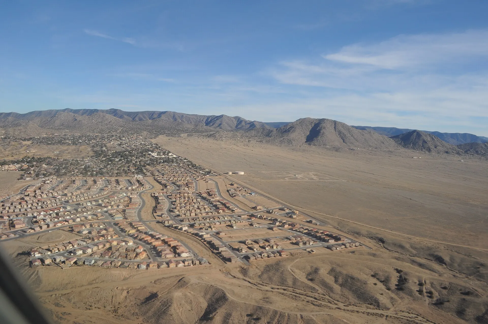
Aerial view including Juan Tabo Hills and Four Hills Village — southeast Albuquerque context. January 2013.
Aerial view including Juan Tabo Hills and Four Hills Village — southeast Albuquerque context. January 2013.
Creator: Joe Mabel
License: CC BY-SA 3.0
Joe Mabel
Changes: Source-supplied resized rendition imported; re-encoded as WebP/AVIF for delivery. No content edits.
A neighborhood park, community programs and East Gateway transit
Around the area
Around this neighborhood

About Singing Arrow
Singing Arrow is an established residential neighborhood in southeast Albuquerque, near the Sandia and Manzano foothills. It combines a mix of housing options with access to neighborhood recreation, shopping along Central Avenue, and public transportation connections.
StrollPlace walkability
53/ 100
The middle 80% of residents in the estimate lived on blocks that scored 37–72.
Estimated access on foot to everyday destinations.
About this estimate
Destinations include groceries, pharmacies, parks, transit stops, cafés, restaurants, shops and schools. The range covers the middle 80% of residents in the estimate.
We estimate the walking distance from each populated Census block’s reference point to the nearest mapped place in each category. A walk of five minutes or less earns full credit. Credit falls to zero at 20 minutes. Groceries count for the most. The area score weights each sampled block by its Census population.
We could route from 17 blocks representing 100% of the area’s reference population. The model estimates route distance and uses a fixed walking speed. Sidewalk condition, shade, and crossing comfort are outside this version’s scope.
Living in Singing Arrow
Singing Arrow is an established residential neighborhood in southeast Albuquerque, near the Sandia and Manzano foothills. It combines a mix of housing options with access to neighborhood recreation, shopping along Central Avenue, and public transportation connections.
One of its most useful features is Singing Arrow Park and the adjacent community center, which provide outdoor recreation, fitness facilities, and organized activities for residents of different ages.
For prospective residents, the main questions are housing condition, school assignments, everyday convenience, transportation, and the differences between individual streets.
Neighborhood Overview
Singing Arrow is generally bounded by Central Avenue to the north, Juan Tabo Boulevard to the west, Four Hills Road to the east, and the Tijeras Arroyo to the south.
The neighborhood includes established residential streets, apartment communities, and nearby commercial services. Its location provides access to Interstate 40, Central Avenue, and the wider East Gateway area.
Living conditions vary by address. Homes near Central Avenue may offer convenient access to transit and shopping but experience more traffic activity. Properties closer to the southern edge may have views toward the Tijeras Arroyo and additional drainage or terrain considerations.
Housing and Residential Character
Singing Arrow offers a combination of single-family homes, townhouses, and apartment properties, giving buyers and renters several housing types to consider.
Many of the neighborhood's homes are established properties rather than new construction. Architectural styles, floor plans, outdoor spaces, and maintenance conditions vary.
Some properties feature stucco exteriors, garages or driveways, and desert landscaping. Apartment communities may provide different amenities and maintenance arrangements.
Before purchasing a home, buyers should review:
Roof condition, insulation, and heating and cooling systems.
Plumbing, electrical systems, and the age of major components.
Yard drainage, grading, and foundation conditions.
Parking availability and access from surrounding streets.
Possible HOA fees, deed restrictions, and maintenance obligations.
Renters should confirm utility costs, parking rules, pet restrictions, and responsibility for repairs.
The Singing Arrow Neighborhood Association offers a way for residents to participate in local discussions, but neighborhood association membership does not automatically establish mandatory HOA obligations for individual properties.
Schools and Education
Singing Arrow is served by Albuquerque Public Schools (APS). Schools associated with the area include:
Apache Elementary School — 12800 Copper Street NE, serving elementary grades. The school's published attendance information specifically includes the Singing Arrow neighborhood.
Kennedy Middle School — 721 Tomasita NE, serving middle school students.
Manzano High School — 12200 Lomas Boulevard NE, serving grades 9–12.
Apache Elementary identifies Kennedy Middle School and Manzano High School as its usual receiving schools.
However, neighborhood names do not guarantee school assignments.
Important: Families should confirm the assigned schools for their exact home address using the APS school boundary lookup. Enrollment requirements, special programs, transfers, and transportation eligibility should also be checked directly with APS.
Parks, Recreation, and Children's Activities
Singing Arrow Park:
Located at 12929 Piru Boulevard SE, Singing Arrow Park is an important neighborhood recreation space.
The park includes grassy areas, walking paths, picnic facilities, a basketball court, and views toward the Tijeras Arroyo.
Its playground was renovated in 2025 with updated climbing equipment, slides, natural play elements, and landscaping. The improvements also include an overlook area with seating.
The park offers space for short walks, outdoor play, and informal recreation without requiring a trip to a larger regional park.
Singing Arrow Community Center:
At 13200 Wenonah Avenue SE, the Singing Arrow Community Center is one of the neighborhood's strongest everyday amenities.
The city-operated facility offers:
Fitness facilities and exercise opportunities.
Karate, yoga, tai chi, and other scheduled classes.
Game and computer rooms.
Youth activities and seasonal programs.
After-school programming serving designated elementary schools.
Meeting and activity spaces.
Community center membership is free, although registration is required and particular programs may have additional eligibility or scheduling requirements.
Families should confirm school pickup arrangements, program registration, age restrictions, and current availability before relying on after-school care.
The center also provides a local fitness option for residents who do not want to depend entirely on commercial gyms.
Additional Recreation:
The wider southeast Albuquerque area offers access to other parks, recreation facilities, and the Manzano Mesa Multigenerational Center.
The National Museum of Nuclear Science & History, located farther west on Eubank Boulevard, is another regional destination for educational visits and family outings.
While the foothills are accessible by car, Singing Arrow should not be confused with neighborhoods that offer direct access to mountain trailheads from residential streets.
Grocery Stores and Everyday Shopping
Central Avenue is the main nearby commercial corridor, providing access to grocery stores, restaurants, and other everyday services.
Useful grocery destinations include:
Smith's Food and Drug — 200 Tramway Boulevard SE, with groceries, a pharmacy, and additional services.
Sprouts Farmers Market — 13150 Central Avenue SE, in Four Hills Shopping Center, offering produce and a selection of specialty grocery products.
Four Hills Shopping Center and surrounding commercial areas also provide additional shopping, dining, and personal services.
For public library services, residents can visit Lomas Tramway Library, at 908 Eastridge NE, in the wider Northeast Heights area.
Walking access to stores varies by street. Residents living nearer Central Avenue may find some errands more manageable on foot, while others will prefer driving.
Prospective residents should check pedestrian crossings, sidewalk conditions, and actual walking distances rather than relying only on a property's proximity to commercial areas on a map.
Transportation and Commuting
Singing Arrow benefits from access to several major transportation corridors.
Central Avenue connects the neighborhood with other parts of Albuquerque, while Juan Tabo Boulevard provides north–south connections. Interstate 40 is accessible to the north.
Unlike some of Albuquerque's more isolated foothills neighborhoods, Singing Arrow also has multiple public transportation options.
ABQ RIDE Routes 1, 66, and 777 serve the Central Avenue and Singing Arrow Community Center area.
Route 777, the ART Green Line, provides a connection along Central Avenue toward Downtown and other destinations farther west.
ABQ RIDE currently operates a zero-fare system, although routes, frequency, and service arrangements can change.
The community center is also listed as a Park & Ride location.
For residents who rely on transit, the key considerations are:
Walking distance to the nearest usable stop.
Service frequency and operating hours.
Transfers needed to reach work or school.
Sidewalks, major road crossings, and nighttime travel conditions.
A vehicle remains useful for many errands and destinations outside the main transit corridors.
Practical tip: Test commuting routes during regular travel hours and review current ABQ RIDE schedules before committing to a property.
Healthcare and Medical Access
Singing Arrow does not have a major hospital within the neighborhood itself.
Residents can access medical providers elsewhere in east Albuquerque, including primary care, dental services, urgent care, and specialized clinics.
Examples of facilities in the wider area include:
UNM Family Health Clinic, Southeast Heights — 8200 Central Avenue SE, providing primary care services.
Duke City Urgent Care — 11601 Montgomery Boulevard NE, offering treatment for non-emergency illnesses and injuries.
Smith's Food and Drug at Tramway and Central also provides pharmacy services.
Major hospitals, including UNM Hospital, are located farther from the neighborhood and require additional travel.
Residents with regular medical needs should evaluate actual travel times, insurance coverage, provider availability, and transportation options from their prospective address.
Safety and Environmental Considerations
Safety should be considered at the property and street level rather than through broad neighborhood labels.
The Albuquerque Police Department provides a public crime-mapping resource that residents can use to review reported activity in specific areas.
These records represent calls for service and do not necessarily indicate confirmed crimes or complete crime trends.
Prospective residents should also visit their chosen street at different times to assess lighting, traffic, parking, pedestrian conditions, and surrounding activity.
Traffic and Noise:
Central Avenue and Juan Tabo Boulevard carry more traffic than interior residential streets.
Properties near these roads may experience additional vehicle noise, commercial activity, or traffic during commuting hours.
Homes farther inside the neighborhood may have different surroundings, so comparing individual locations is important.
Drainage and Flood Risk:
The Tijeras Arroyo forms the southern edge of Singing Arrow and is a major natural drainage corridor.
Heavy rainfall during Albuquerque's monsoon season can produce fast-moving runoff in arroyos and drainage channels.
Homes near the southern neighborhood boundary should be evaluated for drainage conditions, erosion, grading, and any applicable flood hazards.
Flood exposure is property-specific and should not be assumed to affect the entire neighborhood equally.
Buyers can use the FEMA Flood Map Service Center and local mapping resources as starting points for investigation.
Climate and Property Maintenance:
Albuquerque's dry climate, strong sun, and seasonal temperature changes can affect housing maintenance.
Residents should consider cooling efficiency, roof condition, landscaping water requirements, and the condition of exterior materials.
Pet owners should also be mindful of hot pavement in summer and supervise animals around natural drainage areas.
Advantages and Considerations
What Residents May Appreciate:
A mix of established single-family homes, townhouses, and apartments.
Singing Arrow Park and its renovated playground.
A city community center with fitness facilities and youth programs.
Access to groceries and other services along Central Avenue.
Multiple public transit connections.
Convenient road connections to other parts of Albuquerque.
Potential Drawbacks:
Traffic and noise may be more noticeable near major roads.
Housing condition and maintenance needs vary across older properties.
Some errands and medical appointments still require driving.
School transportation and after-school eligibility must be confirmed.
Properties near the Tijeras Arroyo may require additional drainage evaluation.
Walkability depends substantially on the specific street and destination.
What to Verify Before Buying or Renting
Before deciding on a home in Singing Arrow, investigate the following:
School assignment: Confirm the designated schools, transportation eligibility, and enrollment options for the exact address.
Daily convenience: Check realistic walking or driving routes to groceries, pharmacies, parks, and other frequently visited services.
Public transportation: Identify nearby stops and verify schedules for the routes you would actually use.
Property condition: Inspect roofing, HVAC, plumbing, electrical systems, drainage, and previous repairs.
Environmental exposure: Review flood information and any drainage concerns associated with the property.
Safety and surroundings: Consult official records and visit the street during different periods of the day.
Restrictions and costs: Confirm HOA obligations, rental conditions, insurance availability, and expected maintenance expenses.
Is Singing Arrow a Good Place to Live?
Singing Arrow may appeal to residents looking for an established Albuquerque neighborhood with access to local recreation, community programs, shopping, and public transportation.
The combination of Singing Arrow Park and the community center is a particular advantage for people who value nearby opportunities for exercise, activities, and community participation.
The neighborhood also offers several housing types, although their condition, location, and maintenance requirements can differ considerably.
For prospective residents, the best decision comes from comparing individual addresses. A home near transit and shopping may support a different daily routine than one closer to the arroyo or farther from major roads.
Singing Arrow is worth considering for those who want an established residential setting with everyday amenities nearby, provided the specific property meets their transportation, school, housing, and lifestyle needs.
Disclaimer: This guide is intended for general relocation research. School boundaries, transportation services, safety conditions, property restrictions, healthcare availability, and environmental risks may change or vary by address. Verify important information with official agencies, property professionals, insurers, and service providers before making housing decisions.
Compare surrounding Albuquerque areas
Explore the linked profiles to compare housing settings, public services and everyday travel in surrounding areas. Nearby areas can have overlapping names or different jurisdiction and property rules.
Neighborhoods and districts near Singing Arrow
The closest neighborhoods and districts in Albuquerque, measured center to center.


Sources & data notesReferences, reporting periods, and how to use this information
Information on this page is compiled from multiple sources and provided for general information. It may be incomplete or out of date, and we do not guarantee its accuracy, completeness, or timeliness. Independently verify important details with the original source, relevant authority, or a qualified professional before making decisions.
Statistics keep their reporting periods. Survey estimates are not current asking prices or quotes for an individual property. Displayed values are rounded.
- Local relocation research and address-specific verificationmsc.fema.gov — HomepageSource checked
- Local relocation research and address-specific verificationCity of Albuquerque — Routes And SchedulesSource checked
- Local relocation research and address-specific verificationAlbuquerque Public Schools — Attendance AreasSource checked
- Local relocation research and address-specific verificationanthropop.com — Singing Arrow ParkSource checked
- Local relocation research and address-specific verificationCity of Albuquerque — Singing Arrow Community CenterSource checked
- Association context; not a parcel boundary or mandatory HOA determinationCity of Albuquerque — neighborhood associations and mapsSource checked
- Public park addresses and local recreation destinationsCity of Albuquerque — park locationsSource checked
- Branch schedules and current service availabilityPublic Library — locations and service noticesSource checked
- Calls for service do not establish confirmed crime totals or neighborhood crime trendsAPD — calls-for-service map and limitationsSource checked
- Published school catalog information; verify address-based assignmentManzano High — school profileSource checked
- Published school catalog information; verify address-based assignmentApache Elementary — school profileSource checked
- Published school catalog information; verify address-based assignmentTomasita Elementary — school profileSource checked
- Published school catalog information; verify address-based assignmentKennedy Middle — school profileSource checked
- Provider locations and services; confirm availability and insurance directlyUNM Health — primary-care clinic locationsSource checked
- Provider locations and services; confirm availability and insurance directlyUNM Health — UNM HospitalSource checked
- Compare nearby areas; neighborhood labels can overlapJuan Tabo Hills — area profileSource checked
- Compare nearby areas; neighborhood labels can overlapSouth Los Altos — area profileSource checked
- Compare nearby areas; neighborhood labels can overlapSupper Rock — area profileSource checked
Photo credits
- Representative image. See the caption for the place shown.Aerial view including Juan Tabo Hills and Four Hills Village — southeast Albuquerque context. January 2013.Image credits and license
Aerial view including Juan Tabo Hills and Four Hills Village — southeast Albuquerque context. January 2013.
Creator: Joe Mabel
License: CC BY-SA 3.0
Joe Mabel
Changes: Source-supplied resized rendition imported; re-encoded as WebP/AVIF for delivery. No content edits.