


Neighborhood in Albuquerque · Bernalillo County
Supper Rock
Supper Rock is an established residential neighborhood in eastern Albuquerque, known for its distinctive rock formation, neighborhood park, and proximity to the Sandia Mountains.
Photo 1 of 1

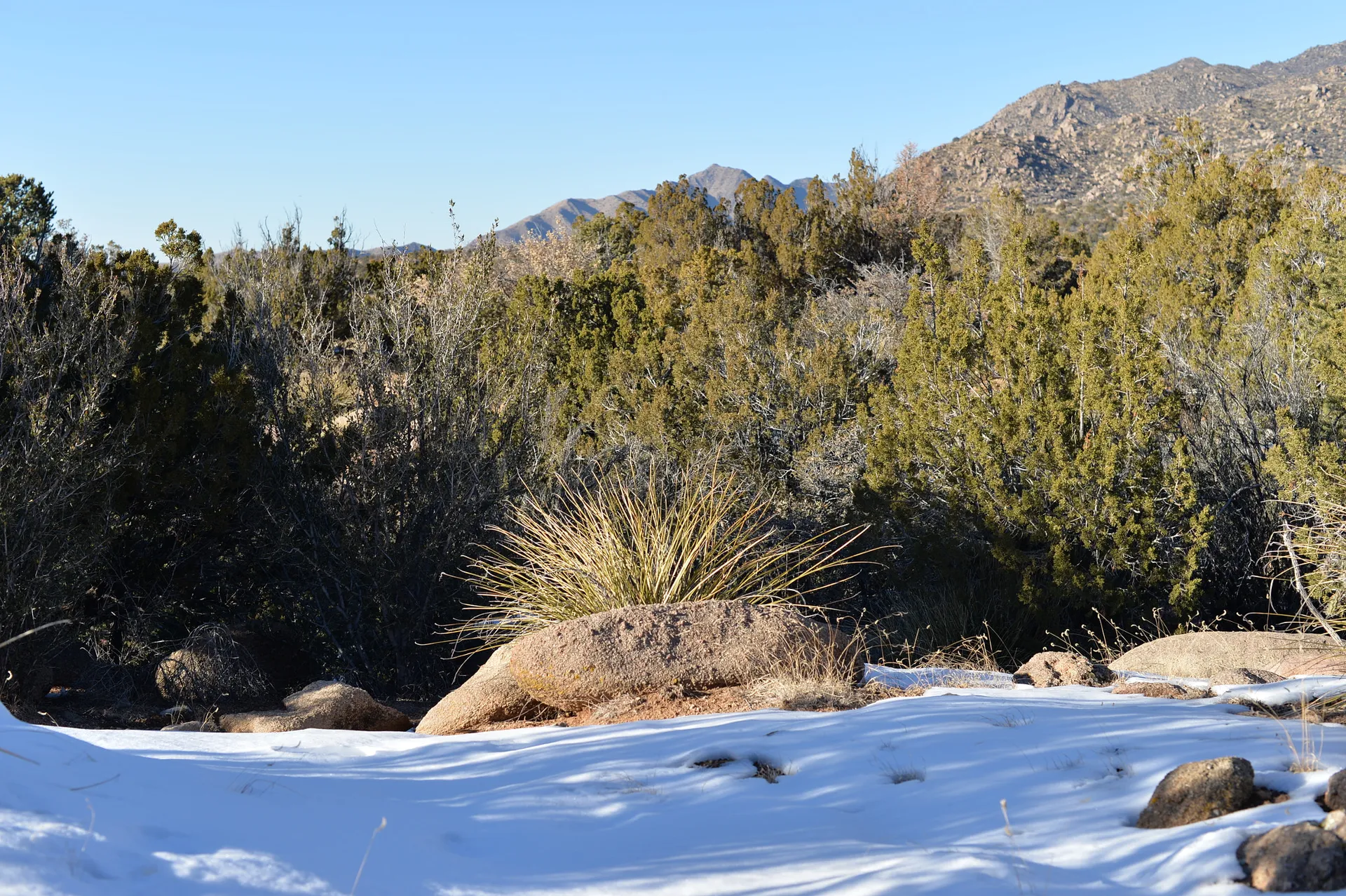
Elena Gallegos Open Space, a separate recreation destination in the wider Sandia foothills. December 2013.
Elena Gallegos Open Space, a separate recreation destination in the wider Sandia foothills. December 2013.
Creator: Andrew Collins
License: CC BY 3.0
Andrew Collins
Changes: Resized and converted to WebP/AVIF. No content edits.
Foothill homes and a distinctive neighborhood rock formation
About Supper Rock
Supper Rock is an established residential neighborhood in eastern Albuquerque, known for its distinctive rock formation, neighborhood park, and proximity to the Sandia Mountains. It combines older single-family homes, quiet residential streets, and access to shopping and services along nearby commercial corridors.
StrollPlace walkability
47/ 100
The middle 80% of residents in the estimate lived on blocks that scored 27–74.
Estimated access on foot to everyday destinations.
About this estimate
Destinations include groceries, pharmacies, parks, transit stops, cafés, restaurants, shops and schools. The range covers the middle 80% of residents in the estimate.
We estimate the walking distance from each populated Census block’s reference point to the nearest mapped place in each category. A walk of five minutes or less earns full credit. Credit falls to zero at 20 minutes. Groceries count for the most. The area score weights each sampled block by its Census population.
We could route from 30 blocks representing 98% of the area’s reference population. The model estimates route distance and uses a fixed walking speed. Sidewalk condition, shade, and crossing comfort are outside this version’s scope.
Living in Supper Rock
Supper Rock is an established residential neighborhood in eastern Albuquerque, known for its distinctive rock formation, neighborhood park, and proximity to the Sandia Mountains. It combines older single-family homes, quiet residential streets, and access to shopping and services along nearby commercial corridors.
For prospective residents, Supper Rock offers an alternative to newer subdivisions, with varied housing styles and a recognizable neighborhood landmark. However, daily convenience depends on the exact address, particularly when it comes to schools, shopping, transportation, and property maintenance.
Neighborhood Location and Character
Supper Rock is located in Albuquerque's eastern Heights, in the area surrounding Supper Rock Park and the Tramway Boulevard corridor.
The Supper Rock Neighborhood Association represents ten subdivisions and was established in 1987. Because the neighborhood includes several residential developments, housing characteristics and property restrictions can differ between streets.
The neighborhood takes its name from the prominent rock formation preserved within Supper Rock Park.
Today, that landmark is preserved within Supper Rock Park, surrounded by residential streets.
Most everyday commercial activity takes place outside the interior neighborhood, particularly along Tramway Boulevard, Central Avenue, and other nearby commercial corridors.
Residents should consult the City of Albuquerque's recognized neighborhood association map to confirm whether a specific property falls within the association's boundaries.
Housing and Property Considerations
Supper Rock consists primarily of detached single-family homes developed during different periods of Albuquerque's eastward expansion.
Housing styles vary, including Southwestern-influenced properties, stucco exteriors, traditional ranch-style homes, and properties that have undergone substantial renovations.
Buyers should evaluate:
Roofing and exterior condition: Roof maintenance, stucco damage, and evidence of previous water intrusion.
Plumbing and electrical systems: Age, materials, capacity, and documented improvements.
Heating and cooling: Equipment condition, insulation, and energy efficiency.
Drainage and grading: Water movement around foundations, driveways, and landscaped areas.
Outdoor maintenance: Irrigation systems, mature trees, desert landscaping, and retaining walls where present.
Renovation history: Permits for additions, structural modifications, and major system upgrades.
Some homes may date from before 1978, making federal lead-based paint disclosure requirements relevant to applicable sales and rentals.
The neighborhood association is separate from any mandatory HOA that may apply to an individual parcel. Buyers should verify recorded covenants, deed restrictions, easements, and any required fees before purchasing.
Schools and Education
Supper Rock is within the Albuquerque Public Schools (APS) district.
Public schools in the surrounding area include:
Collet Park Elementary School — 2100 Morris Street NE. A public elementary school serving Pre-K through fifth grade.
Grant Middle School — 1111 Easterday NE. A public middle school serving grades 6–8. The school also provides community-oriented resources and before- and after-school programs.
Manzano High School — 12200 Lomas Boulevard NE. A public high school serving grades 9–12.
These schools are nearby educational facilities, not guaranteed attendance assignments for every Supper Rock address.
Families should verify school eligibility using the official APS Attendance Areas resources.
Before moving, parents should also check school bus eligibility, travel times, extracurricular offerings, and after-school care arrangements.
Grocery Stores, Shopping, and Everyday Services
Supper Rock is predominantly residential, but several commercial areas serve the surrounding eastern Albuquerque neighborhoods.
Smith's Food and Drug — 200 Tramway Boulevard SE
Located near Tramway and Central, this full-service supermarket provides groceries, household essentials, a pharmacy, and grocery pickup services.
Sprouts Farmers Market — 13150 Central Avenue SE
Located in the Four Hills Shopping Center, Sprouts offers fresh produce, grocery staples, and natural and specialty food products.
Additional restaurants, convenience stores, personal services, and retail businesses can be found along Central Avenue and surrounding commercial corridors.
Although these shopping destinations are accessible from Supper Rock, most residents will find a vehicle useful for routine errands.
Walking convenience varies significantly. Properties closer to major roads may have shorter routes to certain businesses, while interior streets are more residential.
Before choosing a home, residents should map their actual routes to groceries, pharmacies, fitness facilities, and other frequently visited destinations.
Parks, Playgrounds, and Outdoor Recreation
Supper Rock Park — 600 Monte Alto Place NE
Supper Rock Park is the neighborhood's most recognizable public space.
The park includes:
A children's playground
Open green areas
Benches and picnic facilities
Walking opportunities
The historic Supper Rock formation
The rock formation gives the park a distinctive landscape and connects the neighborhood with Albuquerque's early history.
The park also serves as a location for neighborhood gatherings organized by the Supper Rock Neighborhood Association.
City View Estates Park — 901 Jewel Avenue NE
Another nearby public park provides additional outdoor space for residents exploring the surrounding area.
Sandia Foothills Recreation
The Sandia Mountains and their foothill trail system are located farther east. Residents interested in hiking, trail running, or mountain biking can explore designated trails within Albuquerque's open-space network.
Access depends on the trailhead and route selected, and should not be assumed to be directly available from every residential street.
Families should also consider trail difficulty, sun exposure, seasonal temperatures, and wildlife when planning outdoor activities.
Children's Activities, Libraries, and Community Programs
Families have access to recreational and educational resources beyond the neighborhood park.
Lomas Tramway Library — 908 Eastridge Drive NE
This public library provides books, educational materials, digital resources, and access to the Albuquerque–Bernalillo County library system.
Families can check the library's current calendar for children's activities, reading programs, and community events.
Manzano Mesa Multigenerational Center — 501 Elizabeth Street SE
This city-operated center provides recreational opportunities for different age groups.
Facilities and programs include:
Youth recreation and supervised activities
Before- and after-school programming
Fitness and recreational facilities
Sports and community activities
Seasonal outdoor water recreation
The surrounding Manzano Mesa recreation area includes playgrounds, sports fields, and walking paths.
Children's program eligibility, registration requirements, transportation arrangements, and availability should be verified directly with the center.
Private sports clubs, martial arts studios, dance schools, and other extracurricular programs can also be found elsewhere in eastern Albuquerque.
Transportation, Walkability, and Commuting
Supper Rock is generally more convenient for residents who have access to a vehicle.
Driving: Tramway Boulevard provides an important north–south connection. Central Avenue, Lomas Boulevard, and Interstate 40 provide access to other parts of Albuquerque.
Public Transportation: ABQ RIDE operates several routes in the broader area, including:
Route 11 — Lomas: Serves the Lomas Boulevard corridor and connections toward the eastern side of Albuquerque.
Route 66 — Central Avenue: Provides service along Central Avenue.
ART Green Line 777: Connects the eastern Central Avenue corridor with destinations farther west across Albuquerque.
These services do not mean that every Supper Rock home is close to a bus stop.
Residents should check current route maps, active stops, walking distances, and schedules through ABQ RIDE.
Walking: Residential streets and nearby parks offer opportunities for local walks. However, most shopping trips require longer walks or driving, and pedestrian conditions vary near major roads.
Cycling: Some local streets may be suitable for casual cycling, while connections across Tramway and other busy roads require additional attention.
Anyone commuting to Downtown Albuquerque, the University of New Mexico, or another employment center should test the route during normal commuting hours.
Healthcare and Medical Services
Supper Rock residents can access healthcare providers throughout eastern Albuquerque and the Northeast Heights.
New Mexico Urgent Care — 10820 Comanche Road NE, Suite A
This walk-in clinic provides treatment for non-emergency illnesses and injuries, along with selected routine medical services.
Presbyterian Kaseman Hospital — 8300 Constitution Avenue NE
The hospital campus provides emergency and other healthcare services, with additional outpatient and specialist services available through associated medical offices.
Residents can also access pharmacy services at Smith's on Tramway and other commercial locations.
Before moving, people who require regular medical treatment should verify provider availability, insurance-network participation, appointment scheduling, and travel times.
Urgent care facilities should not be treated as substitutes for emergency departments when emergency medical care is needed.
Safety and Environmental Considerations
Safety in Supper Rock should be evaluated using current, address-specific information rather than neighborhood-wide claims.
The Albuquerque Police Department Crime Mapping resource provides information about police calls for service.
APD cautions that these records do not represent all investigated crimes or their final outcomes and should not be used independently to establish crime trends.
Several additional considerations are relevant to properties in this part of Albuquerque.
Wildlife: The Supper Rock Neighborhood Association has established a Bear Safety Project to help residents report bear activity and access safety information from New Mexico wildlife authorities.
Residents should secure trash and food sources, supervise pets, and follow official guidance when wildlife is observed.
Wildfire exposure: Properties near natural vegetation may require additional attention to landscaping, defensible space, exterior materials, and insurance coverage. Exposure varies by location and should be evaluated individually.
Drainage and flash flooding: Heavy rainfall can produce fast-moving runoff in Albuquerque. Buyers should assess grading, drainage channels, and any history of water intrusion.
Traffic and noise: Homes near Tramway, Central Avenue, or other busy streets may experience different traffic conditions than those farther inside the neighborhood.
Older property systems: Some homes may require electrical, plumbing, roofing, or cooling upgrades depending on their age and renovation history.
Visiting a property at different times of day can help prospective residents assess parking, lighting, noise, and general street activity.
What to Check Before Choosing a Home
Before buying or renting in Supper Rock, prospective residents should investigate the individual property and its surrounding streets.
Verify neighborhood boundaries. Confirm the property falls within the recognized Supper Rock area.
Check school assignments. Use the exact address through APS and confirm transportation eligibility.
Inspect the home. Review roofing, plumbing, electrical systems, heating and cooling, drainage, and documented renovations.
Review property restrictions. Check recorded covenants, easements, zoning, and any mandatory HOA requirements.
Map everyday errands. Compare routes to groceries, pharmacies, healthcare providers, parks, and recreational facilities.
Test transportation. Evaluate driving routes, active bus services, and walking conditions.
Review environmental considerations. Check local drainage, flood exposure, wildfire-related conditions, and wildlife precautions.
Visit more than once. Observe traffic, parking, lighting, pedestrian activity, and noise at different times of day.
The City of Albuquerque GIS Maps can help residents access property information, neighborhood boundaries, and other location-specific resources.
Is Supper Rock a Good Place to Live?
Supper Rock may appeal to people who prefer established residential neighborhoods, enjoy nearby parks, and want access to the Sandia Mountains without living in a remote location.
The neighborhood's distinctive rock formation, local park, and community association contribute to its individual character.
For families, the availability of playgrounds, nearby schools, a public library, and city recreation programs may be useful. However, school assignments and activity arrangements should always be verified.
Residents who rely primarily on public transportation or want most errands within walking distance may find some locations less convenient.
For buyers, the age and condition of individual homes deserve particular attention. Maintenance requirements, renovation history, and property restrictions can vary significantly.
Supper Rock's suitability ultimately depends on the exact address, property condition, access to everyday services, and how well the location supports a household's daily routine.
Disclaimer: This guide is intended for general informational purposes and does not constitute real estate, legal, financial, insurance, or safety advice. School assignments, business operations, transit services, property restrictions, and local conditions may change. Buyers and renters should independently verify information for the exact property address before making a housing decision.
Compare surrounding Albuquerque areas
Explore the linked profiles to compare housing settings, public services and everyday travel in surrounding areas. Nearby areas can have overlapping names or different jurisdiction and property rules.
Neighborhoods and districts near Supper Rock
The closest neighborhoods and districts in Albuquerque, measured center to center.


Sources & data notesReferences, reporting periods, and how to use this information
Information on this page is compiled from multiple sources and provided for general information. It may be incomplete or out of date, and we do not guarantee its accuracy, completeness, or timeliness. Independently verify important details with the original source, relevant authority, or a qualified professional before making decisions.
Statistics keep their reporting periods. Survey estimates are not current asking prices or quotes for an individual property. Displayed values are rounded.
- Local relocation research and address-specific verificationCity of Albuquerque — Abq LibrarySource checked
- Local relocation research and address-specific verificationCity of Albuquerque — Routes And SchedulesSource checked
- Local relocation research and address-specific verification
- Local relocation research and address-specific verificationCity of Albuquerque — GisSource checked
- Local relocation research and address-specific verificationCity of Albuquerque — Crime MappingSource checked
- Local relocation research and address-specific verification
- Local relocation research and address-specific verificationAlbuquerque Public Schools — Attendance AreasSource checked
- Local relocation research and address-specific verificationsupper-rock.org — About.HtmlSource checked
- Local relocation research and address-specific verificationsupper-rock.orgSource checked
- Local relocation research and address-specific verificationCity of Albuquerque — ResourcesSource checked
- Local relocation research and address-specific verificationsupper-rock.org — Bear Watch.HtmlSource checked
- Local relocation research and address-specific verificationCity of Albuquerque — Park AddressesSource checked
- Published school catalog information; verify address-based assignmentManzano High — school profileSource checked
- Published school catalog information; verify address-based assignmentGrant Middle — school profileSource checked
- Published school catalog information; verify address-based assignmentCollet Park Elementary — school profileSource checked
- Provider locations and services; confirm availability and insurance directlyNew Mexico Urgent Care — current clinic locationSource checked
- Provider locations and services; confirm availability and insurance directlyPresbyterian — healthcare facilities and providersSource checked
- Compare nearby areas; neighborhood labels can overlapEastridge — area profileSource checked
- Compare nearby areas; neighborhood labels can overlapEmbudo Canyon — area profileSource checked
- Compare nearby areas; neighborhood labels can overlapSinging Arrow — area profileSource checked
Photo credits
- Representative image. See the caption for the place shown.Elena Gallegos Open Space, a separate recreation destination in the wider Sandia foothills. December 2013.Image credits and license
Elena Gallegos Open Space, a separate recreation destination in the wider Sandia foothills. December 2013.
Creator: Andrew Collins
License: CC BY 3.0
Andrew Collins
Changes: Resized and converted to WebP/AVIF. No content edits.